Menu

Smart Home Geofencing

Digitally map development sites with geofenced plots, real-time inventory, and GPS navigation for customers—powered by IndianRFID.

Smart Home Geofencing from IndianRFID helps builders and developers design precise layouts, manage plot inventory, and guide customers to home locations using GPS. Draw house rows, plots, roads, and amenities on satellite maps, track real-time status of each home, and share accurate coordinates with buyers—without relying on paper-based plans or manual directions.

Key Features
Site Layout Creation

Design complete housing layouts on satellite maps

Enter the development site address and start drawing rows, individual house plots, roads, gates, and community areas on Google Maps satellite view. Quickly adjust and refine layouts as the project evolves.

Site layout creation for housing projects
Real-Time Inventory Management

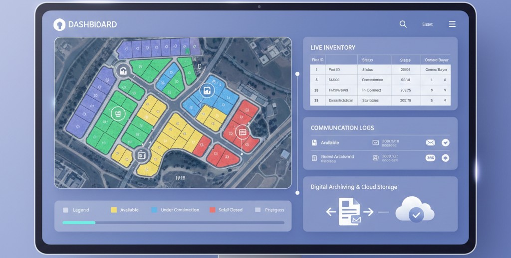
Track plot status across the entire site

Maintain a live inventory of homes marked as new, in-contract, closed, or available. Visual indicators on the map help teams instantly see the status of each plot and overall project progress.

Real-time inventory management for plots
Customer Navigation

Send GPS coordinates directly to buyers

Click any plotted house to extract exact XY coordinates and share them via email. Customers can open the link in Google Maps or Apple Maps and navigate directly to their future home without confusion.

Customer navigation to home plots
Paperless Documentation

Keep all layouts and records fully digital

Replace manual paperwork with automatic digital records for plot layouts, inventory status, and communication history. Updates are stored in real time, reducing errors and administrative effort.

Paperless documentation for developers
Nearby Amenities Mapping

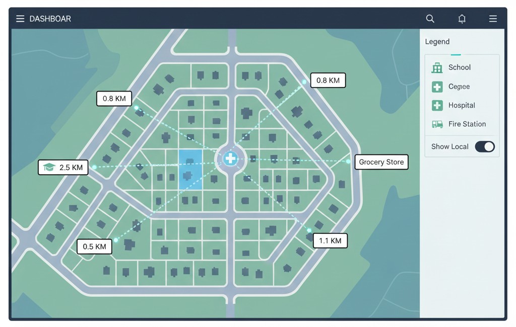
Show schools, hospitals, and key amenities

Mark nearby schools, hospitals, grocery stores, fire stations, and other amenities. Measure and display distances from each plot, giving customers clear insight into connectivity and convenience.

Amenities mapping around housing projects
Key Benefits
Streamlined site planning
Real-time plot inventory
Clear communication with buyers
Fewer errors than manual methods
Faster sales and decision making
Reduced dependency on paper records
Centralized, always-updated data
Improved customer site visit experience
Scalable across multiple projects
Who Can Use Smart Home Geofencing?
Residential real estate developers
Township and plotted development projects
Builders & construction firms
Real estate marketing & sales teams
Industrial park & mixed-use planners
Smart city and urban planning agencies
Government & public housing authorities
Consultants working on land development
Why Choose IndianRFID?

IndianRFID combines geofencing, mapping, and real-time data into a single tool built for developers and planners. Smart Home Geofencing helps you digitize layouts, maintain accurate inventory, provide buyers with seamless navigation, and operate with a fully paperless workflow. From planning to implementation, IndianRFID supports you end-to-end.

Start a Conversation

Hi! Click one of our solutions below to chat on Whatsapp

The team typically replies in a few minutes.